To address the growing challenges of extreme weather events, Taipei City has been actively implementing “sponge city” strategies in recent years. These efforts build on earlier initiatives from the early 2000s, when the city launched its Comprehensive Flood Management Strategy.
Designed for highly urbanized areas like Taipei, where expanding existing flood control infrastructure is often unfeasible, the strategy focuses on a three-tiered approach:
“retaining water upstream, mitigating floods midstream, and preventing floods downstream.”
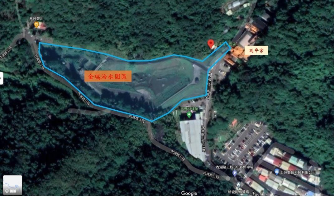
As part of the midstream flood mitigation component, the Hydraulic Engineering Office (HEO) of the Public Works Department, Taipei City Government launched the Phase 1 Planning and Design of Stormwater Retention and Detention Basins in Taipei City in 2006. The study identified suitable urban sites where detention basins could be constructed to reduce pressure on downstream drainage systems during heavy rain events. This particular detention and sedimentation basin is located in the mountainous catchment area managed by the Yangguang and Gangqian Pumping Stations in Neihu District. The upper reaches of Lane 348, Section 3, Neihu Road, fall within a designated debris flow potential stream, while the lower area has experienced significant flooding, especially during Typhoon Nari. After assessing land availability and strategic value, the site was prioritized for development and construction commenced soon after.
Entrance to Jinrui Flood Management Park
Catchment Area Overview, Flooded Zones during Typhoon Nari, and Debris Flow-Prone Rivers Upstream


(1) Project Overview
The detention basin is located in a valley at the intersection of hillside and flatland in Section 3 of Neihu Road, west of Lane 348, within Jinrui Borough, Neihu District. The primary facilities include: a headworks structure, elevated drainage box culvert, detention basin, pedestrian landscape bridge, maintenance access road, emergency overflow structure, outflow regulation facility, water level gauge, and CCTV monitoring system. The project covers a total area of approximately 1.827 hectares, with a catchment area of about 211 hectares, and was designed to store up to 27,000 cubic meters of stormwater, with a maximum basin depth of around 6.5 meters. Construction commenced in February 2014 and was completed in March 2015. Following its completion, the facility was officially named Jinrui Flood Management Park through a public naming initiative.
(2) Detention Mechanism
This facility adopts an off-channel detention basin design. A diversion structure is installed at the upstream headworks, consisting of an overflow weir and an elevated drainage box culvert. Under normal conditions, when the water level remains below the crest of the overflow weir, most of the flow is diverted downstream via the elevated box culvert without entering the detention basin. A small outlet at the base of the weir allows a constant trickle to maintain flow in the ecological pond. During typhoon or flood events, when water levels rise above the overflow weir, a portion of the stormwater continues to discharge downstream through the elevated box culvert, while the excess water overflows into the detention basin. This regulates peak flow and reduces the burden on the downstream stormwater drainage system.
Jinrui Flood Management Park Guide Sign

Headworks Structure

Detention Mechanism – Diagram 1

Detention Mechanism – Diagram 2

(1) The park was designed for multi-functional use. Beyond flood detention, it serves as a public space for exercise, leisure, and ecological education during non-flood periods. A dry detention basin design was adopted, allowing the entire park to provide both disaster prevention and recreational value, with rich biodiversity and a tranquil natural environment ideal for weekend outings.
(2) The project applied eco-engineering methods. Stone excavated on-site was reused as construction material for channel renovation. This not only ensured effective use of resources and reduced construction costs, but also enhanced the ecological and scenic value of the channels.
(3) Both the inlet and outlet of the detention basin were designed with gravity-based drainage, including an elevated drainage box culvert and overflow weir at the headworks. Flow control does not require mechanical or manual operation—even during rainfall or emergency drainage—eliminating the need for pumps. This reduces operational risks, lowers maintenance requirements, and supports energy conservation and carbon reduction.
(4) The slopes of the basin feature a frog stone water gauge, an ecological design element that allows visual interpretation of water depth while contributing to the natural and aesthetic landscape.
Upstream Eco-Friendly Drop Structure and Dry-Laid Stone Revetment

Non-Mechanical Elevated Drainage Culvert and Overflow Weir at the Headworks

Frog Stone Water Gauge

2015: Taipei City Public Works Beautification and Environmental Landscape Award
2016: FIABCI-Taiwan Real Estate Excellence Awards – Special Award in Best Planning and Design Category
2020: 8th Taiwan Landscape Awards – Honorable Mention in Environmental Facility Category

In addition to its disaster prevention function, Jinrui Flood Management Park is a green, scenic haven that offers Taipei residents a space for recreation and exercise. The park features a lakeside pedestrian trail, flower planting zones, and a viewing platform on the levee top, where visitors can enjoy panoramic views of the surrounding landscape. Nearby destinations such as Jinmian Mountain Trailhead, Jinlong Zen Temple, Zheng Chenggong Temple, and Bishanyan Temple make the park a perfect gateway for a half-day nature and culture outing. The park's rich ecological features also make it an ideal destination for environmental education.
Levee-Top Pavilion and Seating Area

Jinrui “Dragonfly” Pavilion
Stone-Paved Walkways

Basin Floor Landscaping

Pedestrian Trail System Around the Detention Basin
Nearby Tourist and Recreational Attractions


Completed at the end of 2024, the Jinrui “Dragonfly” Pavilion offers stunning panoramic views. Designed with minimal environmental impact, it carefully blends into its surroundings.Constructed primarily with 100% sustainably harvested local timber, the pavilion’s structure features red copper roof tiles that naturally patinate over time to harmonize with the landscape. A handcrafted mosaic of stained glass in the shape of a dragonfly’s vibrant wings adds a colorful accent. Locally sourced materials were prioritized not only to reduce the carbon footprint of long-distance transport, but also to ensure that the warm, natural tones would gradually blend into the environment—evolving with time and place as part of the living landscape.
Design Philosophy
We chose only local and on-site materials—Because that is nature.
We crafted as much as possible by hand—Because we are human.
We interpreted space and meaning through abstraction—Because art begins in the heart.
We let the landscape dissolve into the site itself—Because nature speaks for itself.
Site Selection and Overall Planning Rationale

Design Layout for Box Culvert Platform Pavilion
Entrance Area Design and Spatial Arrangement
Tangible Net-Zero Carbon Emission Benefits

Neihu is a biodiversity hotspot for Odonata (dragonflies and damselflies) within the Taipei Basin. The diverse aquatic environments surrounding Jinrui Flood Management Park—ranging from foot-hill streams and irrigation channels to ponds—offer ideal habitats for these insects.
Through regular ecological monitoring and species surveys within the park, researchers have recorded rich biodiversity among birds, butterflies, amphibians, and particularly Odonata, with 73 documented species, representing one-third of all species found in Taiwan.
Notable sightings include the common moorhen and the elusive white-breasted waterhen, along with a variety of native aquatic plants such as crested floating heart (Nymphoides hydrophylla) and yellow water lilly (Nuphar shimadae), further illustrating the area’s ecological richness.
In collaboration with Neihu Community College, the park serves as a demonstration site for hydrology and ecological education. Through civic engagement, the community actively participates in habitat restoration, site maintenance, species monitoring, and water conservation outreach—bridging nature, education, and citizen stewardship.
Red percher (Neurothemis ramburii )

Formosan damselfly (Euphaea formosa)

Asian pintail (Acisoma panorpoides)

In 2019, focused habitat improvements were carried out based on the park’s rich ecological characteristics, particularly its value as an Odonata habitat. Centered on the theme of dragonflies, these efforts aimed to support the restoration of dragonfly biodiversity not only in Neihu District but across the broader Taipei Basin. This initiative marked the park as Taipei City's first official “Dragonfly Habitat Park”, providing an engaging natural space for community participation and urban nature education.
Jinrui Dragonfly Habitat Enhancement Plan Diagram

Address:Lane 348, Section 3, Neihu Road, Neihu District, Taipei City
Transportation:By Bus – From MRT Neihu Station Exit 2, take Bus 222, 247, 521, 551, 552, 553, 679, or Blue 27 to “Jinlong Temple Stop”. Walk approximately 500 meters to reach the park.

![Taiwan.gov.tw [ open a new window]](/images/egov.png)